
Las Arkoński: a forest park on moraine hills
The Arkoński Forest Park (Park Leśny Arkoński), also called the Las Arkoński Natural Area (Uroczysko Las Arkoński) or simply Laskiem, bore the German name Eckerberger Wald until 1945. According to Wikipedia, it covers 976.9 hectares in the northern and north-western part of Szczecin, in the Warszewo Hills, and is a fragment of the Wkrzańska Forest. The terrain is undulating: the difference in height is about 100 metres, from the Warszewo Plateau, which reaches 120 metres above sea level, to Lake Głębokie at an altitude of 19 metres.
The forest contains pines, beeches, oaks, birches, poplars and alders, and some species, such as European larch and Douglas fir, were introduced by people. The highest elevations in the park are Arkona Hill (70.3 metres) and Sobótka Hill, at about 70 metres. The streams Osówka, Arkonka, Zielonka and Kijanka flow through it, and in the hollows lie the small lakes Goplany and Głuszec and ponds, including the Syrenie Stawy (Mermaid Ponds). According to Wikipedia, the name of the park refers to Arkona, the centre of the cult of Svetovid, and members of the religious association “Rodzima Wiara” hold celebrations of their festivals in the forest.
Trails through the forest and across the hills
Several marked routes lead through the park. The green “Through Las Arkoński and the Warszewo Hills” trail is about 13.8 kilometres long and runs through Niemierzyn, Osów, the southern part of the Wkrzańska Forest and Przęsocin to Skolwin. The red “Wild Boar Paths” trail (Ścieżkami Dzików) is about 14.5 kilometres long, begins in Niemierzyn, leads through the park and Osów, passes Wielecka Góra and ends in Police-Mścięcino. Neither is a loop, so before setting out it is worth planning the return and checking the waymarking on the spot.
The Quistorp Tower and the Syrenie Stawy
On Arkona Hill in 1900-1904 stood a viewing tower, which Martin Quistorp built as a tribute to his father Johannes, a Szczecin manufacturer and philanthropist. The design was made by the Berlin architect Franz Schwechten. According to Wikipedia the tower was 45 metres high, and a summer café operated on the first storey. Wikipedia writes about its end differently in two places: the entry on the tower gives two versions, destruction in an Allied air raid in 1944 or blowing up by the Germans in 1945, and the entry on Arkona Hill gives the date 25 April 1945. Today what remains are ruins entered in the heritage register, since 2008 lying on the educational trail “In the Footsteps of the Quistorps” (Śladami Quistorpów). At the Quistorp Tower one should not enter overgrown sections or the underground parts.
The Quistorp family is also connected with the valley below the hill. According to Wikipedia, at the end of the 16th century a sheep farm called Eckerberg stood here, burnt down in 1677, then a farmstead of the same name, and in 1808-1813 French military barracks. In the second half of the 19th century a hydropathic establishment operated here, which Johannes Quistorp bought in the 1870s. After 1890 a sanatorium of the Ernst Moritz Arndt foundation was built on this site, with the Lindenhof restaurant beside it. In 1908 Martin Quistorp sold the town the land of today's Syrenie Stawy for 3.5 million marks of the time.
The foundation existed until 1945. Of the whole complex the larch manor house on Międzyparkowa Street survived, entered in the heritage register in 1983. The Syrenie Stawy are fed by the Osówka and lie in the Niemierzyn Valley, about three kilometres from the town centre.
Arkonka, Goplany and the Valley of the Seven Mills
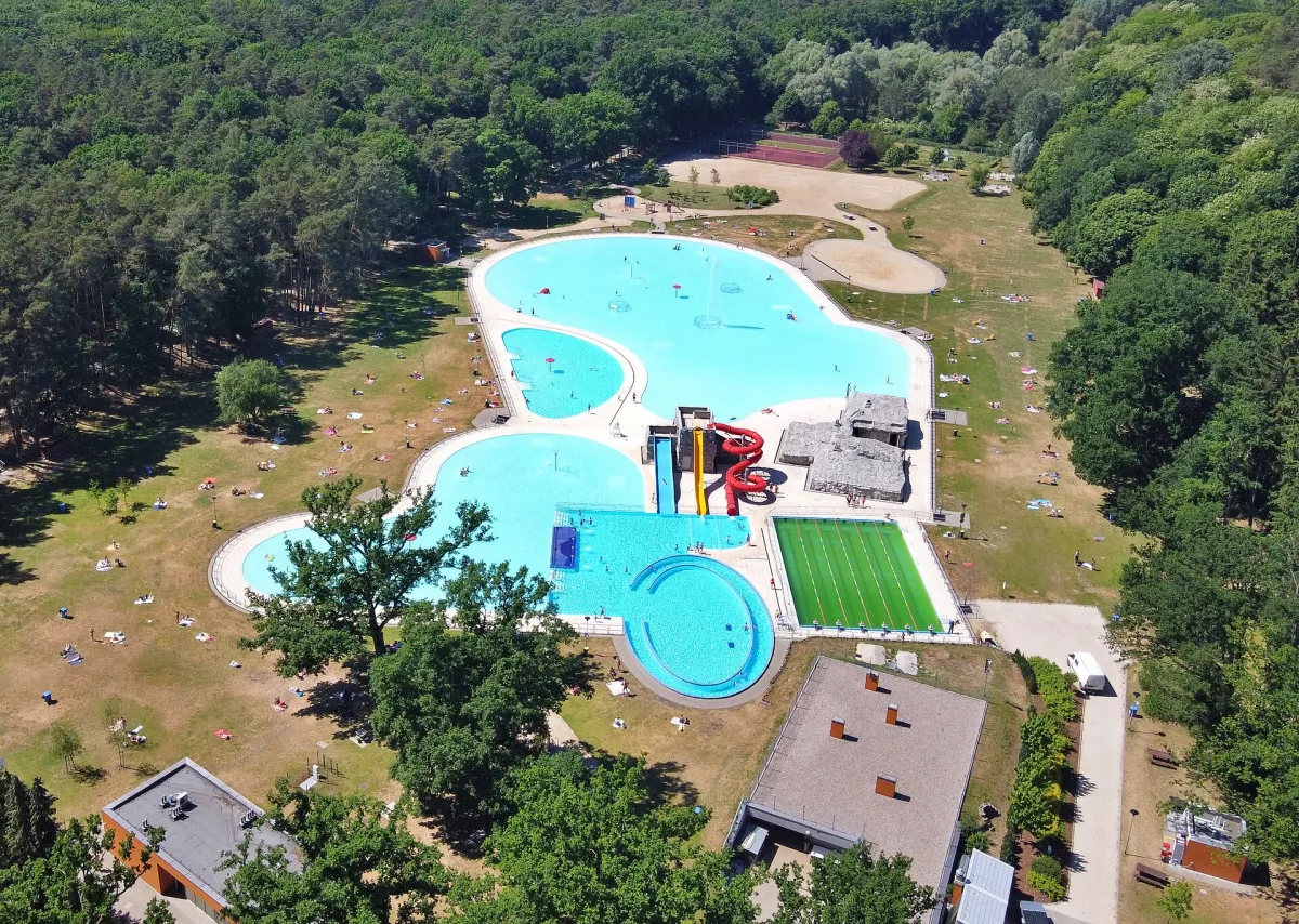
Arkonka, formerly called Świtezianka and until 1945 Martin See, is a former lake. According to Wikipedia, the municipal bathing complex was created at the beginning of the 20th century in the basin of a drying reservoir, and in the southern part of the lake stood the water mill Steinfurther Mühle. A thorough modernisation was completed in 2014. The complex covers 7 hectares and has four pools with a total area of 8,012 square metres, of which the largest, Morze (the Sea), is 4,990 metres, plus water slides, an artificial river, a playground and a skatepark. To Arkonka one travels by tram to the Las Arkoński stop, and from there it is about 200 metres on foot.
The name Arkonka is also borne by a stream about 2.1 kilometres long. Its sources lie on the Morena, in the Osowa estate, at an altitude of about 90 metres, and it flows into Lake Goplany, which until 1945 was called Sand See. According to Wikipedia, in the 20th century there was a bathing place here, later closed.
The Valley of the Seven Mills (Dolina Siedmiu Młynów), situated between Głębokie and Osów, took its name from the seven mills on the Osówka. According to the Encyclopaedia of Szczecin, the Ustronie mill existed before 1277, because in that year Duke Barnim I sold it to the town, and in 1643 the remaining mills passed into the town's ownership. At the turn of the 19th and 20th centuries the valley was turned into a recreation area: restaurants were set up in three mills, holiday homes in three others, and in 1925 an entertainment venue was created in the former Ustronie mill. The valley forms part of a nature and landscape complex, and the Polish-German trail “Seven Mills - Gubałówka” runs through it.
On the eastern edge of the forest lies Lake Głębokie, formerly Glambeck See, with an area of 31.3 hectares. Wikipedia gives its maximum depth once as 5 and once as 6 metres. In 1418 Dukes Otto II and Casimir V agreed to divert water from the Osówka into it, and a bathing place on the lake was built in the 1920s. Around the lake runs a red walking trail about 6 kilometres long.
The Warszewo Hills and the former village of Warszewo
The Warszewo Hills are moraine hills, partly within the boundaries of Szczecin and partly in Police County. The highest point is, according to Wikipedia, Wielecka Góra: the entry on the hills gives 131 metres, and the entry on the hill itself 130.9 metres. The summit lies in the municipality of Police, right by the northern border of the city. Wikipedia also notes that the tops of the hills are good viewpoints over the Beech Hills, the Goleniów Plain, Lake Dąbie and the Szczecin Lagoon, and from some places in Stołczyn and Skolwin in good visibility the cliffs of Wolin Island can be seen. One such place is the viewpoint on Górska Street.
The hills took their name from the village of Warszewo, today an estate of Szczecin. According to Wikipedia, it lies at an altitude of 110 metres above sea level, that is, 85 metres higher than the city centre. The settlement was founded in the 13th century as an owalnica (an oval village), which can still be seen in the layout of Poznańska and Szczecińska Streets. In 1271 Duke Bogislaw IV gave the village to the Cistercian convent, and the document was confirmed in writing in 1276. Warszewo was included within the borders of Szczecin in 1939.
A medieval church was first mentioned in 1283. In 1874 the brick St Anthony of Padua's Church was built on its site, with a tower changing into an octagon, whose stained glass was made by Wiktor Ostrzołek. After the war it was taken over by Catholics and was consecrated on 14 October 1945.
On the southern slopes of the hills, in the Żelechowa estate, lies Brodowski Park. It was created in the 1970s after the clearing of the site of the former Brodowski Cemetery, a pre-war complex of municipal cemeteries destroyed in 1944 by Allied air raids. The old paths and monumental oaks have survived.

Be the first! Add a comment.
You need to log in to add a comment.
Log in