
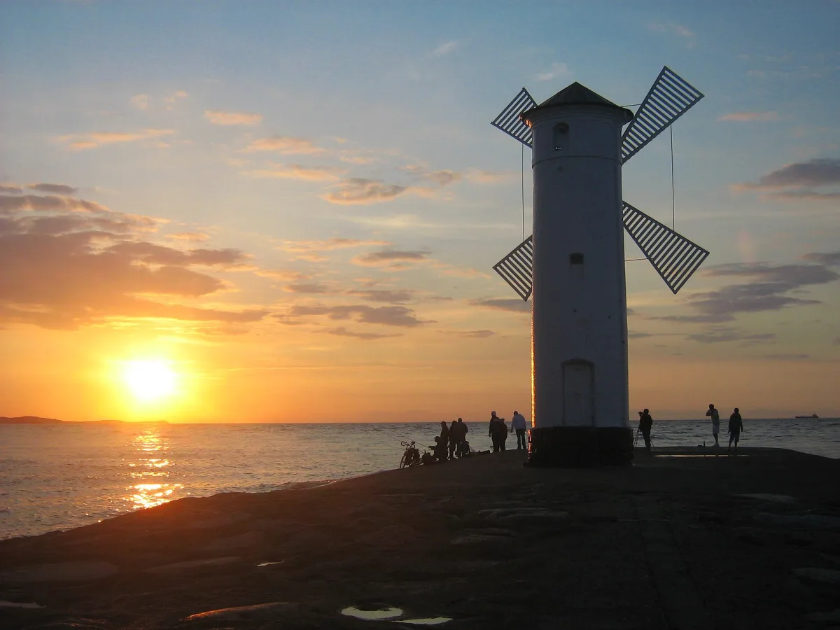
Anyone sailing to Świnoujście from the Baltic first sees not the town but a few marks: a long stone line of breakwaters, a white silhouette at the end of one of them and a tall tower behind the beach. Each of them has a different task in this entrance. This text sorts them out one by one, from the sea into the mouth of the Świna.
Stawa Młyny: a mark that looks like a windmill
According to Wikipedia Stawa Młyny is a historic beacon (stawa), that is a fixed navigation mark, shaped like a windmill, standing at the end of the West Breakwater at the mouth of the Świna into the Baltic. It is 10 metres high, white with a black roof, and was built in 1873-1874, during the modernisation of the fairway. It is not a lighthouse, although it is commonly called one. The stawamlyny.pl website notes that the structure was never a mill, and its form merely evokes an association with a windmill.
Why a windmill, none of the sources checked explains. What is known, however, is what the beacon is for. Wikipedia describes how, together with the Galeria beacon, lying 522 metres to the south, it marks a leading line on a bearing of 170°12', that is the line a ship keeps on approaching the port. At the top of Stawa Młyny is the front light of the leading line: white, flashing, in a ten-second cycle, at a height of 11 metres above the water, with a range of 17 nautical miles.
It is also a symbol of the town. Wikipedia writes that it forms part of the official logo of Świnoujście, and photographs of the beacon are a standing element of postcards and guidebook covers. In 1976 the structure served as a film set for The Lighthouse Keeper (Latarnik), directed by Zygmunt Skonieczny, and for the time of filming a small building and a balcony were added, and removed when the work was finished.
A local legend circulates about the beacon, which Wikipedia presents as a legend, not a fact. The tale says that a sailor's wife, Alicja, heard a voice by the sea at night telling her to seek help from the miller in the windmill. The old miller was said to have rejuvenated her husband, exhausted by voyages, with a cure of mud, sea bathing and walks, and when he died himself, the secret of the treatments vanished with him.
The Świna Gate and the breakwaters
The name Świna Gate (Brama Świny) has two meanings. According to Wikipedia it is a physico-geographical microregion within Uznam and Wolin on the Pomeranian Bay, and also a narrowing of the Świna strait in which water is exchanged: fresh water flowing down the Świna into the bay and sea water from the bay into the Szczecin Lagoon. Until 1945 the German name Swinepforte was used, and the Polish name was fixed officially in 1949. Wikipedia also draws attention to the nature of the spit: the largest stand of sea sandwort on the Polish coast grows there.
The mouth of the Świna, that is the Świna Gate itself, was according to Wikipedia enclosed in 1818-1823 by two stone breakwaters. Today's arrangement is more extensive. Wikipedia lists three harbour breakwaters in Świnoujście. The West Breakwater, the one with Stawa Młyny, is according to it about 350 metres long, but the article on the port of Świnoujście gives about 300 metres for it and marks this as information without a footnote, so the length should be treated as approximate. The Central Breakwater on the right bank, on Wolin, is more than 1400 metres long and according to Wikipedia is the longest stone breakwater in Europe. The East Breakwater, built in 2010-2013 for the new outer port, is almost 3000 metres long, and Wikipedia states that a reinforced-concrete spur about 250 metres long was added to the Central Breakwater at that time.
By the west breakwater lies, according to Wikipedia, the West Shoal (Mielizna Zachodnia), mentioned in the article on the port of Świnoujście in the description of the entrance to the port.
From the sea to the Lagoon: the second gate
According to Wikipedia the fairway from Szczecin to the sea is marked by four fairway gates. One of them is the entrance from the Szczecin Lagoon into the Piast Canal, sheltered by its own breakwaters on both sides of the canal, on the south side of Karsibór island. Wikipedia states that the eastern one is 430 metres long and the western one 550 metres, and both replaced breakwaters destroyed in the early 20th century.
The tower behind the beach: the lighthouse
The tall tower nearby is already a real lighthouse. According to Wikipedia its light was lit on 1 December 1857, the tower is 67.7 metres high, and 308 steps lead to the top. Wikipedia calls it the tallest lighthouse on the Polish Baltic coast. According to Wikipedia the white light of the lighthouse has a nominal range of 25 nautical miles, and the front light of Stawa Młyny 17 miles.
Be the first! Add a comment.
You need to log in to add a comment.
Log in