
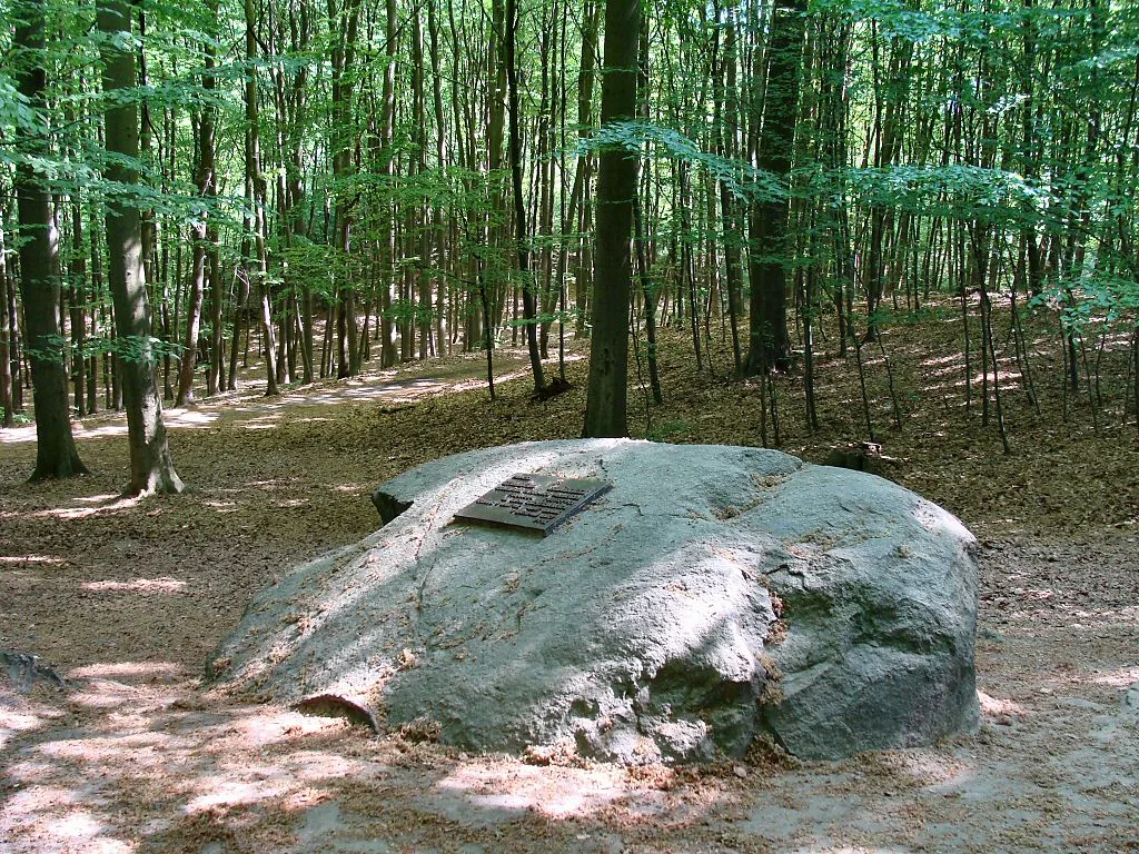
The Beech Hills near Szczecin were shaped by the Scandinavian ice sheet, and it left behind the blocks of rock that we now call erratic boulders. The manager of the landscape park has counted them and gives the figure of 880, and the best known have their own names, plaques and places along the trails.
Where the 880 boulders come from and what the figure covers
According to the Complex of Landscape Parks of the West Pomeranian Voivodeship, the Scandinavian ice sheet, moving south, sometimes picked up whole blocks of rock and left them where it melted. Some boulders lie on the surface, and some are hidden underground and may be revealed by erosion. In the area of the Szczecin Landscape Park “Puszcza Bukowa” and its buffer zone, 880 such formations have been inventoried, as the manager writes. Wikipedia, in its entry on the Beech Forest, gives the same figure, but applies it to the forest itself, not to the park with its buffer zone. Neither source gives the year of the inventory or its author.
Wikipedia adds a breakdown by size: several dozen boulders have a circumference above 7 m, and several hundred smaller ones above 4 m. It also notes that in the past there were many more, because the local population used them to build walls and cobbled roads.
Ten natural monuments, four proposed
The park manager lists ten boulders protected as inanimate natural monuments: the Sightseers' Boulder (Głaz Krajoznawców), the Cradle (Kołyska), the Boulder by Leśna Road, the Heart Boulder known as the Mill Boulder (Głaz Serce zwany Młyńskim), Groński's Boulder, an unnamed boulder in compartment 238h of the Klęskowo forest district, Anna and Andrzej, the Mossy Boulder (Głaz Omszały), the Swedish Boulder and the Słupi Głaz Boulder. Wikipedia sets them out in a table that gives the circumference and height above ground, and adds four boulders that are proposed or currently not counted as monuments: Słupieniec, Ukryty (the Hidden One), Błażej and the boulder by the motorway.
The most interesting are the details from this table that are not in the descriptions of the trails. The Boulder by Leśna Road, grey granite, has a circumference of 14.2 m, but protrudes only 50 cm, because it is sunk in the ground. The Hidden Boulder, one of those proposed, has a circumference of 12.8 m and a height of 1.8 m. The Mossy Boulder, biotite granite, has a circumference of 9.8 m, the Swedish one 9.1 m, and the Słupi one 8.7 m. The Swedish Boulder is gneiss with a pegmatite vein, and Błażej is rapakivi granite, coarse-grained and pink. Anna and Andrzej are two blocks side by side: the first has a circumference of 10.9 m and a height of 1.5 m, the second 9.5 m and 0.9 m. To this list Wikipedia adds the Miedwie Stone, known as the Devil's Boulder, with a circumference of 9.4 m, which is in Kołbacz, formerly in the area of Dębina.
The names are not consistent: the manager writes “Szwedzki Głaz”, Wikipedia's table “Głaz Szwedzki”, and the list in the entry on the Beech Hills “Szwedzki Kamień”. The highest in the table is the Sightseers' Boulder at 2.7 m, and the same block has the largest circumference, 17.5 m. The red Trail via the Słupi Głaz Boulder leads past the boulder of that name, and the yellow Bolesław Wrymouth Trail passes the Sightseers' Boulder at 2.8 km of the route.
Groński Road and the boulder bound for Berlin
Groński Road runs along the southern foot of Chojna Hill. At its junction with Chojnowska Road, Wikipedia describes a junction of marked trails. More on the patron of the boulder below. On its southern side lies the natural monument Groński's Boulder, a grey-pink gneiss with a circumference of 12.3 m and a height of 1.4 m, with a visible hole left by an explosive charge.
In its entry on the Beech Forest, Wikipedia describes anecdotes about the fates of boulders. According to the first, a cobbled road to Kołowo was built from a gigantic boulder near Dobropole. Immediately after it, the entry states that a boulder lying by Groński Road was used to build elements of the colonnade of the National Gallery in Berlin. The entry gives neither a source nor the name of a specific boulder, and Groński's Boulder still lies by that road today. We therefore treat this as a story, not a confirmed fact.
Stanisław Groński, patron of the boulder
Until 1957 Groński's Boulder was called Bolek's Boulder in honour of Bolesław Wrymouth, and according to Wikipedia also Świętochowski's Stone. It owes its present name to Stanisław Groński. He was born on 7 September 1907 in Drohobych as Stanisław Wróbel, and took the surname Groński from the village of Groń, where his family came from. He was a Polish mountaineer, and after the war settled in Szczecin and worked in the railways. Together with Wincenty Zając he founded the Szczecin Mountaineering Club, and in the PTTK (Polish Tourist and Sightseeing Society) he held many functions.
The Beech Hills were his favourite place. According to Wikipedia he began marking trails here and left about 300 km of marked routes, and the first Polish guidebook to these hills, “Knieja Bukowa”, was published in 1953. Groński's name is borne today by the blue Stanisław Groński Trail, 38.2 km from Szczecin Zdroje station to the Szczecin Zdunowo stop. The black Bukowiec Mountain Trail passes this boulder after 1.0 km.
In August 1957 Groński died in the Mont Blanc massif. He set out on 7 August with two Yugoslav mountaineers by the route over Mont Blanc du Tacul and Mont Maudit and did not return, and searches found no trace of them. According to the account by Czesław Momatiuk cited in Wikipedia, all three probably fell into a crevasse. On 23 August 1959 the PTTK placed a marble plaque on the boulder, which was replaced with a metal one in 1976. The inscription reads: “In memory of Stanisław Groński, a leading Polish Tatra climber, pioneer of tourism in the Szczecin Land. He died in the Mont Blanc massif in August 1957”. The boulder was designated a natural monument on 22 December 2004.


Be the first! Add a comment.
You need to log in to add a comment.
Log in