
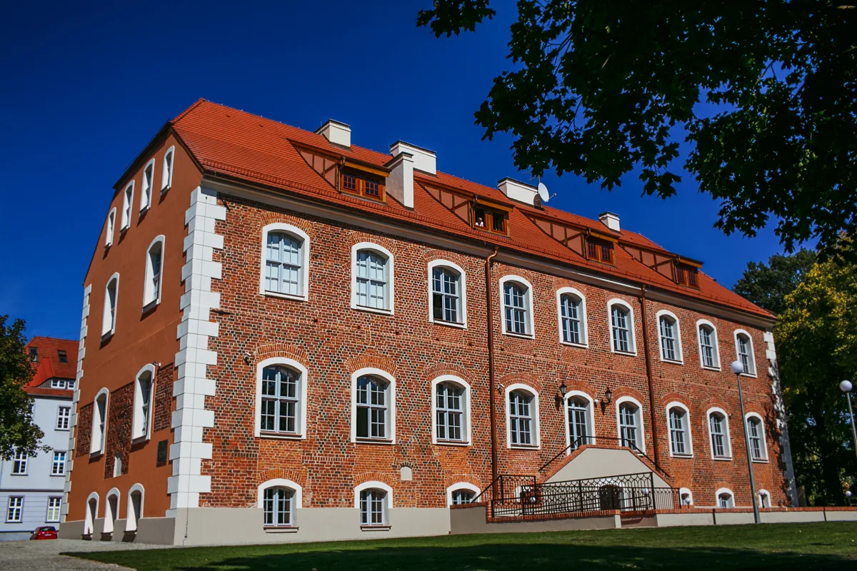
Szczecinek lies on an isthmus between three lakes: Trzesiecko, Wielimie and Wilczkowo. According to Wikipedia they are linked by the Nizica river, which flows through the town centre. The former chartered town thus had water on several sides, and today's walk leads from the castle on Lake Trzesiecko, through the park and the old centre, to the former German shelters on the isthmus. The whole route can be covered on foot, and its points are usually a few hundred metres apart.
A town on an isthmus
According to Wikipedia, Szczecinek was founded in 1310 by Duke Wartislaw IV of Wolgast, who at once granted it town rights. The town's former name, in use until 1946, was Nowy Szczecin (New Szczecin) and referred to Szczecin as the capital of the Duchy of Pomerania. The town arose south of an older fishing settlement, Kiecz, on Lake Wielimie. The site was chosen for defensive reasons: it was surrounded by lake waters, rivers and marshes.
The arrangement of the waters was once different. According to Wikipedia, in 1780-1784 the residents lowered the level of Wielimie and Trzesiecko, and a second lowering was carried out in 1866-1868. Wielimie, according to the entry on that lake, was once much larger and deeper, and its waters surrounded the town from the north and north-west. After the level was lowered the south-western shore turned into extensive quaking bogs, so the lake can practically not be reached from the town side today. Wikipedia also records the German names of the lakes: Streitzig-See for Trzesiecko and Vilmsee for Wielimie. According to it, Trzesiecko also has the name Trzesieka.
Trzesiecko is a ribbon lake up to 5.6 km long and up to 0.9 km wide, entirely within the town limits. Wielimie is much larger than it and lies mainly outside the town. According to Wikipedia, its largest island, Owcza Island (Wyspa Owcza), blocks the view of the main body of water, which is best seen from the village of Gwda Wielka, about 10 km away. A walker in the town therefore has to do mainly with Trzesiecko.
The castle and the park on Lake Trzesiecko
The walk is best begun at the Castle of the Pomeranian Dukes. According to Wikipedia, the south wing dates from the first half of the 14th century and stands on the site of an earlier Slavic stronghold. Later alterations of the 16th, 19th and 20th centuries mean that the castle has not preserved its original character. It originally stood on an island in Lake Trzesiecko, and after the water level was lowered it found itself on a peninsula.
The castle has had a long and varied history. At the end of the 18th century it housed a girth-strap manufactory, from the early 19th century a hospital and almshouse, and after the war the army, then a holiday hostel. In April 1996 the castle was sold. According to Wikipedia it today serves as a conference and hotel venue, and entry to the courtyard for outsiders is practically impossible, so it is best viewed from outside, from the park and from the lake side.
At the foot of the castle begins the Town Park, which stretches along the shore of Trzesiecko from Lelewela Street to the Town Stadium. According to Wikipedia the largest part was laid out in 1875-1903 on ground that had earlier been flooded by the lake. In the interwar years a rose garden and a bandstand were added. The entry lists pedunculate oaks, dogwoods, Swedish whitebeams, horse chestnuts and several natural monuments, as well as exotic species such as the katsura tree and the Douglas fir. According to Wikipedia, under the spell of the park the German composer Richard Strauss wrote the opera Daphne, which premiered in 1938.
Along the lake shore runs a marked blue cycle route around Trzesiecko, 14.5 km long. A water tram runs on the water, and bathing places are designated by the lake, including on Mysia Island (Mysia Wyspa), which is in fact a peninsula. The park ends near the brine graduation tower.
Towers, churches and the old centre
From the park it is worth going into the town, to Wolności Square. The town hall, according to Wikipedia built in 1852 of red brick in an eclectic style with a predominance of Neo-Romanesque elements, has an octagonal tower. Since 1978 a bugle call based on a fragment of the song “Powróciłaś do nas ziemio” by Henryk Łabęda has sounded from it at noon.
Further on stands the Church of the Nativity of the Blessed Virgin Mary, a Neo-Gothic brick church built in 1905-1908 as the Protestant St Nicholas' Church. According to Wikipedia its tower is 78 m high, and inside there is an organ by the Voelkner firm of 1908. Part of the furnishings were moved from the old church, among them the epitaph of Dorota Westreglen of 1621.
The old St Nicholas' Church has vanished from the town, but its tower remains. According to Wikipedia the church was demolished in 1909, preserving only the 16th-century tower, and since 1914 a museum has been housed in it. Today the collections are shown by the Regional Museum on Szkolna Street.
Right next to it, at Szkolna 6, stands the Orthodox Church of the Holy Trinity. It is housed in a building of 1824. According to the heritage register it was originally a synagogue, although Wikipedia also cites another source according to which the building belonged to the Evangelical community. The date of its construction is the same in both versions.
North of the centre, on Klasztorna Street, stands the Church of the Holy Spirit, a Neo-Romanesque church of 1923. It was called the Polish Church, and until 1945 it was the only Catholic church in the town. It was consecrated on 20 December 1923 by Cardinal Adolf Bertram.
According to Wikipedia, a stronghold stood in the early Middle Ages on Przemysł Hill (Wzgórze Przemysława), also called Bismarck Hill. In 1910-1911 the Przemysł II Tower, also called the Bismarck Tower, was built there.
Shelters on the isthmus
The walk can end at a place that shows why the isthmus was so important. According to Wikipedia, the shelters of the Pomeranian Wall were built in 1934-1935 west and north of the town. The reinforced-concrete structures, 25 in all, blocked the isthmus between Lake Trzesiecko and Lake Wielimie. At the end of February 1945 they did not stop the offensive of the Soviet troops, who took the town on 27 February after a day's fighting.
By the road to Barwice stands the largest of them: the two-storey B-Werk, which houses the Museum of the Pomeranian Wall and the Second World War. According to Wikipedia it is the best preserved of the 11 structures of this type on the Pomeranian Wall. The museum is some distance from the centre, so getting there is better planned separately.


Be the first! Add a comment.
You need to log in to add a comment.
Log in