
The Hobrecht plan and the end of the fortress
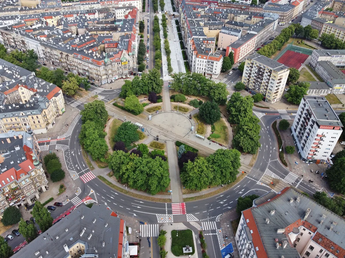
The star-shaped layout of squares and avenues in the centre of Szczecin is linked with the dismantling of the fortress. According to Wikipedia, the first plan for developing the area around today's Grunwaldzki Square was drawn up in the 1860s by the municipal building councillor James Hobrecht. The plan envisaged the city growing to the north-west and linking the then city centre with the Westend district then being built. At the crossing of the two main avenues, today's Pope John Paul II Avenue and Piłsudskiego Street, a representative square was planned, originally rectangular.
The dates vary from entry to entry. In the entry on Pope John Paul II Avenue Wikipedia writes that Hobrecht prepared the concept of the development in 1864 and completed the plan in 1874. The entry on Grunwaldzki Square adds that negotiations with the army, to which the land belonged, stalled, and the plans were returned to once Szczecin ceased to be a fortress. The city council discussed the plan for the development of the city on 31 March 1874. According to that entry, the square itself was created at the end of the 1880s on the site of Fort Wilhelm, which was dismantled in 1884.
Was it Haussmann
After the Second World War a thesis appeared in popular studies and guidebooks that the whole star-shaped layout of Szczecin had been designed by Georges Haussmann, the creator of the 19th-century rebuilding of Paris. Wikipedia states outright that according to the present state of knowledge Haussmann was not the designer of the Szczecin squares. The entry points to a strong similarity of solutions and holds that the Szczecin designs were modelled on Parisian ones, as in many European cities of those years, because Paris was then the centre of Europe. According to the same entry, the thesis of the Frenchman's authorship was willingly maintained by the post-war authorities, because it raised the prestige of the city, and a French designer was politically more convenient than a German one.
The entry on the square also mentions corrections to the Hobrecht plan that were said to have been introduced by Lord Mayor Burscher and building councillor Kruhl, but this passage in Wikipedia has no footnote, so we base no conclusions on it.
Kaiser-Wilhelm-Straße
The axis of the layout today is Pope John Paul II Avenue, which according to Wikipedia is 1.18 km long. It was initially to be named Lindenstraße, after a street in Berlin, but in 1877 it was named after Emperor Wilhelm I, Kaiser-Wilhelm-Straße. In 1882 its final width was set: the section south of Grunwaldzki Square was to be 48 m wide, and north of it 59 m, with front gardens before the townhouses. In 1886-1888 the grammar school building was erected on the avenue, today the university rectorate, and in the following decades the blocks were built up with townhouses.
An example of such development is the August Mintz townhouse of 1898, designed by Georg Sonnenstuhl, on the corner with Śląska Street, right by the square. In the gable of the projecting bay a coat of arms with compasses and a set square was placed, and the inscription “A. D. 1898”. In turn the Wilhelm Gramtz townhouse of 1892-1893 at Śląska 38 forms, together with its twin house at Rayskiego 29, the south-western frontage of the square. Above its gateway stand two putti, one as an allegory of learning, the other of crafts, and the corner oriel is crowned with a helmet with a spire.
The war and what remains after it
In 1944 bombing destroyed the townhouses on the corners of Grunwaldzki Square with Śląska, Rayskiego and Piłsudskiego Streets. The avenue survived until January 1944, and its southern part was almost completely destroyed by the raid of the night of 16 to 17 August. In 1964 the plots were built up with two eight-storey tower blocks by Tadeusz Ostrowski and a low block. In 1952-1954 two Socialist Realist blocks of the Central Residential District were designed between Grunwaldzki Square and Lotników Square, completed in 1958.
Today the layout is best seen in the townhouses that survived. The townhouse at Piłsudskiego 7, completed in 1897 to a design by Sonnenstuhl, is according to Wikipedia the only surviving building of the eastern frontage of Piłsudskiego Street between Grunwaldzki Square and Rodła Square. The latter was shaped after the war, around 1976, on the site of destroyed buildings. The townhouse at Malczewskiego 34, known as the Sandwich (Kanapka), of 1885-1888, is the only surviving pre-war townhouse of its block.
Further squares
Odrodzenia Square, until 1945 Friedrich-Karl-Platz, was designed in 1882 as a roundabout with streets meeting it radially. Around it stand townhouses of several storeys from the end of the 19th century, and some of the former crowning features have not survived. Older in the history of the city is Polish Soldier Square, which according to the description was laid out in 1725 as a parade ground, Königs Platz. According to the description, Pope John Paul II Avenue, among others, leads into it.
Not far away lies Jasne Błonia (the Bright Meadows), laid out in 1925-1927 on land of the Quistorp family. According to Wikipedia, 213 London plane trees grow there, the largest cluster of this species in Poland. Jedności Narodowej Avenue, today Pope John Paul II Avenue, was on 15 July 1945 the route of a solemn march from Jasne Błonia to Grunwaldzki Square. The Polish name of the square was given on that day, on the 535th anniversary of the Battle of Grunwald, and in 1877-1945 the square was called Kaiser-Wilhelm-Platz.


Be the first! Add a comment.
You need to log in to add a comment.
Log in