
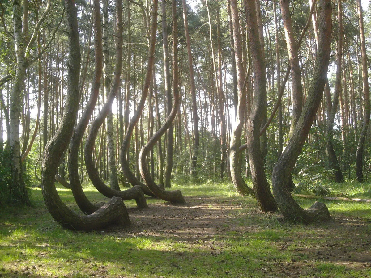
Near Gryfino, in Nowe Czarnowo next to the Dolna Odra Power Station, grows a group of pines whose trunks bend almost horizontally just above the ground and then return to the vertical. The place is known as the Crooked Forest (Krzywy Las), and locals also call it the Fairy-tale Forest (Bajkowy Las). Nobody left a document saying who shaped these trees, or why. What remains are observations, one measurement from 1971 and several hypotheses. Below we separate what can be checked from what is conjecture.
What is known: location, age and protection
According to a walking guide published by the Gryfino municipality, the forest lies four kilometres from Gryfino and belongs administratively to the Gryfino Forest District, Pniewo forest range. Wikipedia describes the trees as Scots pines bent at an angle of about 90 degrees from about 20 cm above the ground, with the curve reaching a height of 3 m in some, at a total height of 11-12 m.
The age of the forest has been established only approximately. Wikipedia says the pines were planted in the 1930s, probably in 1934. The Gryfino municipality's walking guide says the forest is estimated to date from 1934, and the Encyclopaedia of West Pomerania also states that the trees were probably planted in 1934, all at the same time.
Protection: the Encyclopaedia of West Pomerania states that the Crooked Forest was designated an area natural monument by Regulation No. 120/2006 of the Voivode of West Pomerania of 8 November 2006. Wikipedia, citing the Central Register of Forms of Nature Protection, gives 15 December 2006 as the date of designation. The sources therefore agree on the year and differ on the day.
How many trees: four answers
The number of pines and the area of the forest depend on whom you ask:
- Wikipedia: more than 50 trees, a natural monument with an area of about 0.33 ha,
- the Gryfino municipality walking guide: more than 100 pines on an area of 0.5 ha,
- the Encyclopaedia of West Pomerania: a cluster of several hundred pines,
- a measurement from 1971, quoted in the walking guide: 400 trees on 1600 m2.
The measurement from 1971 is, according to the walking guide, the only known dendrological study of the place, made by Prof. Eugeniusz Ćwikliński. It shows that the trees stood in 22 rows 120 cm apart. The walking guide also points out that many trees are drying out. According to the municipality this is a natural process that cannot be stopped. Trees that pose a danger to visitors are removed in accordance with the Nature Conservation Act, and fallen logs are left in place as dead wood, a habitat for insects and fungi.
Hypotheses about its origin
The municipality's guide states outright that the opinions in circulation are accounts handed down by the local population or observations by foresters and scientists, not research results. It lists eight ideas.
Tanks, sledges and carts
According to an account from local residents, quoted in the guide, the young trees may have been damaged by tanks standing in this place in spring 1945. The guide describes this account but does not settle it.
The second group of ideas concerns craft. The guide indicates that the trees may have been shaped for carts used to carry hay from the nearby Międzyodrze (the Oder floodplain) or for the runners of horned sledges. It stresses, however, that any mention of a local craft workshop is hard to find in the available sources. Wikipedia cites the same family of theories, giving as examples crooked timber for joinery and shipbuilding, that is, for building furniture, boats and sledges.
Christmas trees
Wikipedia also cites the television programme “Galileo”, according to which Professor Kremer believed the saplings were cut at the age of 6 to 10 years to be used as Christmas trees. The lower branch that was left continued to grow towards the vertical and in time took the shape of an arch. The municipality's guide describes a similar idea of a Christmas tree plantation, but adds a reservation: the precision of the identical cuts in the rows is puzzling.
A sanatorium, UFOs, an electromagnetic field, pests
The remaining hypotheses from the guide are an amusement for patients of a nearby sanatorium, interference by an alien civilisation, an electromagnetic field and underground water veins beneath the forest, and tree pests or diseases. The guide itself raises, against the last, the question whether a deformation on such a scale and in such a similar way on every tree would be possible at all. For none of these hypotheses does it cite evidence.
Why the municipality leans towards the work of human hands
The last page of the guide indicates that the suggestions about the use of crooked timber by craftsmen seem highly probable, and that the symmetry of the planting speaks for the trees having been shaped by people. This is the assessment of the guide's authors, not the result of a study.
The guide also gives observations that anyone can check on site. All the pines have their curves directed north. On every trunk, just above the ground, thickened grooves can be seen. According to the guide these are traces of the trunk having been cut on the south side at a height of 30-50 cm and the sapling bent towards the north. Further development depended on whether the sapling was left with its top or with one of the side shoots. The authors write cautiously here: “perhaps”.
Testing it in practice: new plantings
In 2020 the Gryfino municipality, the Gryfino Forest District and Polska Grupa Energetyczna began cooperating on the revitalisation of the place, making it available to tourists without interfering with the natural substance of the forest. According to Wikipedia, in 2021 the forest district established next to it a replacement plot with 1,000 young saplings that are to be bent artificially. The guide describes the plan in more detail: on one plot seedlings grown from seeds collected from the trees of the Crooked Forest are to grow, to check whether they repeat the tendency to bend, and on the other the pines will be mechanically deformed using methods that the creators of the forest might have used.
The authors of the guide write that perhaps this will make it possible to answer the question of how the Crooked Forest came into being.
According to Wikipedia, a red hiking trail from Szczecin Klucz to Mieszkowice runs through the area.
Be the first! Add a comment.
You need to log in to add a comment.
Log in