
The commission of 1610
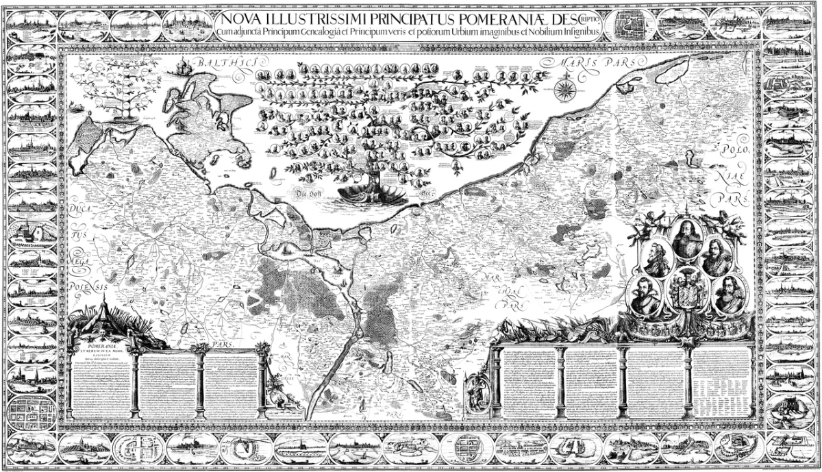
According to Wikipedia, the Great Map of the Duchy of Pomerania was produced in 1610-1618 at the commission of Philip II, Duke of Szczecin. The author was Eilhardus Lubinus, properly Eilert Lübben, who had earlier worked on a map of Rügen. The duke wanted a map of the whole duchy, among other reasons to govern the country better. In a letter of 18 August 1610 to his cousin, Philip Julius, Duke of Wolgast, he wrote that, following the example of other rulers, he had decided to present his duchy on a map.
According to Wikipedia, Lubinus began by gathering information from libraries and ducal archives. In 1611-1612 he analysed it and wrote a 123-page description of the Pomeranian lands. Only then did he set out into the field.
The journey of 1612 and the measurements
Lubinus began his first journey through Pomerania on 19 August 1612. According to Wikipedia he visited 152 places, travelled about 1,500 kilometres and took 5,793 measurements. The German Wikipedia, in its article on Lubinus, speaks of a tour from August to October 1612.
In 1614-1616 Lubinus worked with the duke at the castle in Szczecin on the graphic setting of the map, collecting the coats of arms of the Pomeranian nobility, views of towns and portraits of the dukes. According to the German Wikipedia, the decision to add views of towns, coats of arms and portraits was taken in 1614, which considerably increased the workload. The genealogical tree of the House of Griffin and a description of the country were added as well.
What the map looks like
Wikipedia gives a scale of 1:235,000 and a format of 2.21 by 1.25 m, which was a great achievement for the time. The map was combined with the genealogical tree of the Dukes of Pomerania. Portraits of the dukes were placed in the tree, and the coats of arms of the noble families of Pomerania in the border. Along the outer edge of the sheet, panoramas of the most important towns were arranged, according to Wikipedia mostly made by the Szczecin painter Johann Wolfart.
Wikipedia lists more than forty places that have their own views, among them Szczecin, Stargard, Kołobrzeg, Słupsk, Koszalin, Pyrzyce, Goleniów, Wolin, Kamień Pomorski, Darłowo, Gryfino and the monastery in Kołbacz. There are also towns that today lie in Germany, for example Stralsund, Greifswald, Anklam and Pasewalk.
Printing in Amsterdam
The outline of the map was ready in 1617 and went to the workshop of Jodocus Hondius II. According to the Polish Wikipedia it was engraved by Nicolaus van Geelkercken, and according to the German one it was made in Amsterdam on 12 copperplates, and the sheets were assembled into one map. Older literature, as the Polish Wikipedia notes, assumes printing in Amsterdam on paper from West Pomerania.
Duke Philip II died in 1618 and did not live to see its publication. The Polish Wikipedia writes that the first copies were ready in the autumn of 1618 and that about 30 were produced. The German Wikipedia specifies that in November 1618 Lubinus presented the first copies to Duke Philip Julius in Wolgast.
Disappearance and rediscovery
In 1618 the Thirty Years' War broke out. According to Wikipedia the maps were lost and were found only in 1756 in Stralsund, by chance, thanks to the Szczecin historian Karl Conrad Oelrichs. In 1758 a new edition was published in Hamburg, and the number of prints is not known; it is supposed to be several dozen.
According to the German Wikipedia, the map for a long time formed the basis of printed maps of Pomerania and was repeatedly reworked into atlas maps. The Polish Wikipedia quotes the cartographer Kazimierz Kozica of the Royal Castle in Warsaw, who supposes that about 50 copies of the first and second editions survive to this day, including a dozen or so in Poland. This is one researcher's estimate, not a register of holdings.
Where to look for traces in Szczecin
The Castle of the Pomeranian Dukes in Szczecin published, in a series on the traces of the Dukes of Pomerania, a text on Philip II, Lubinus and the Great Map. This is the castle where, according to Wikipedia, the graphic setting of the map was produced: the Ducal Castle in Szczecin.
Be the first! Add a comment.
You need to log in to add a comment.
Log in